Watershed Characterization
This section provides information on the local climate, demographic history, past and present land cover, underlying soil and geographical characteristics, bathometric and morphometric descriptions, and habitats and wildlife within the Moultonborough Bay and Winter Harbor watersheds. This information helped to guide goal development for protecting the water quality of Moultonborough Bay and Winter Harbor.
2.1 POPULATION, GROWTH TRENDS, AND LAND COVER Return to Top
2.1.1 Watershed and Climate
The Moultonborough Bay and Winter Harbor watersheds are located on the eastern shores of Lake Winnipesaukee within Carroll County, NH. The Moultonborough Bay watershed covers 46.7 sq.mi. within the towns of Tuftonboro (31.9 sq.mi., 68.4%), Moultonborough (12.4 sq.mi., 26.6%), Wolfeboro (4.4 sq.mi., 4.9%), and Ossipee (0.1 sq.mi., 0.1%). The Winter Harbor watershed covers 8 sq.mi. within the towns of Wolfeboro (4.4 sq.mi., 55.6%) and Tuftonboro (3.5 sq.mi., 44.4%). Because only a small portion of forested land area within the Moultonborough Bay watershed is located in Ossipee, the Town of Ossipee will not be included in the summary statistics presented throughout this document.
The Moultonborough Bay Inlet watershed is located to the north of Moultonborough Bay beyond Clark’s Landing and represents the primary inlet to the bay. Within Moultonborough Bay, water flows through six major embayments before mixing with the broader Lake Winnipesaukee beyond Cow Island. These six major embayments include Upper Moultonborough Bay, Melvin Bay, Upper Long Island & Morrison Cove, Twentymile & Nineteenmile Bay, Lower Moultonborough Bay, and Lower Long Island. Inlet waters for Winter Harbor include the Basin, Mirror Lake, and overland flow. Water in Winter Harbor mixes with the Lake Winnipesaukee Broads (The Broads refers to the open, central region of Lake Winnipesaukee) past Thomas and Ayers Points.

Situated within a temperate zone of converging weather patterns from the hot, wet southern regions and the cold, dry northern regions, the Lake Winnipesaukee Region experiences various natural phenomena such as severe thunder and lightning storms, and heavy snowfalls. The area experiences moderate to high rainfall and snowfall, averaging 49.2 inches of precipitation annually. Temperature generally ranges from -5 °F to 85 °F with an average of 19°F in winter and 65°F in summer (NOAA NCEI, 2019; Figure 2-1).
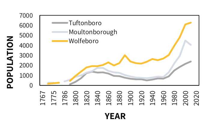
2.1.2 Population and Growth Trends
Lake Winnipesaukee, along with Moultonborough Bay and Winter Harbor, has long been treasured as a recreational haven for summer vacationers and year-round residents. The area is one of the oldest summer vacation spots in NH and offers lifeguarded beaches, fishing, hiking, boating, sailing, canoeing, kayaking, and swimming in the summer, and ice fishing, cross-country skiing, snowshoeing, and snowmobiling in the winter. The Moultonborough Bay watershed makes up 65% of the total area within Tuftonboro, 17% within Moultonborough, and 4% within Wolfeboro. The Winter Harbor watershed makes up 8% of the total area within Wolfeboro and 7% within Tuftonboro. According to the most recent US census in 2010, most housing units within towns of Moultonborough (61%) and Tuftonboro (53%) support a seasonal population (Figure 2-2, Table 2-1). Wolfeboro also supports a significant seasonal population (30%). These seasonal residents continue to flock to the Moultonborough Bay and Winter Harbor watersheds (from Independence Day to Labor Day) to utilize various amenities around the lake including, private and public beaches, marinas, summer camps, cottages, a golf course, and a variety of on-lake boating activities. There is limited public transportation in the area, and most people use personal vehicles in their daily routines.
Understanding population growth and demographics, and ultimately development patterns, provide critical insight to watershed management, particularly as it pertains to lake water quality. According to the U.S. Census Bureau, the population of Carroll County in 2010 was 47,698, representing a 9% increase in population since the 2000 census (NHOEP, 2019; Table 2-2, Figure 2-3). From 1960 to 2010, the population of Moultonborough grew exponentially at an average rate of 911 residents every decade, Wolfeboro at an average of 849 residents, and Tuftonboro at an average of 368 residents. From 2000 to 2010, the population of Moultonborough decreased by 440 residents, while the populations of Tuftonboro and Wolfeboro increased by 239 and 186 residents, respectively. The decrease in population in Moultonborough could be attributed to the dispersal of young adults out of the watershed communities. There were 602 residents in 2000 within the 10-19 age group but only 241 residents in 2010 within the 20-29 age group (NHOEP, 2011) (Table 2-1).
Understanding population growth and demographics, and ultimately development patterns, provide critical insight to watershed management, particularly as it pertains to lake water quality. According to the U.S. Census Bureau, the population of Carroll County in 2010 was 47,698, representing a 9% increase in population since the 2000 census (NHOEP, 2019; Table 2-2, Figure 2-3). From 1960 to 2010, the population of Moultonborough grew exponentially at an average rate of 911 residents every decade, Wolfeboro at an average of 849 residents, and Tuftonboro at an average of 368 residents. From 2000 to 2010, the population of Moultonborough decreased by 440 residents, while the populations of Tuftonboro and Wolfeboro increased by 239 and 186 residents, respectively. The decrease in population in Moultonborough could be attributed to the dispersal of young adults out of the watershed communities. There were 602 residents in 2000 within the 10-19 age group but only 241 residents in 2010 within the 20-29 age group (NHOEP, 2011) (Table 2-1).
The desirability of the towns of Moultonborough, Tuftonboro, and Wolfeboro as seasonal destinations is congruent with many other lakefront communities in the Lakes Region of NH. Growth figures show an influx of residents to the Moultonborough Bay and Winter Harbor communities from 1960 to 2000 that slowed or decreased from 2000 to 2010 (Figure 2-3, Table 2-2). Because of this historical growth pattern, communities within the watershed should consider the effects of current municipal land-use regulations on local water resources. As the region’s watersheds are developed, erosion from disturbed areas increases the potential for water quality decline (refer to Section 3.3.3 for Build-Out Analysis results).
2.1.3 Land Cover
Characterizing land cover within a watershed on a spatial scale can highlight potential sources of NPS pollution that would otherwise go unnoticed in a field survey of the watershed. For instance, a watershed with large areas of developed land and minimal forestland will likely be more at risk for NPS pollution than a watershed with well-managed development and large tracts of undisturbed forest, particularly along headwater streams. Land cover is also the essential element in determining how much phosphorus is contributing to a lake via stormwater runoff and baseflow (see Section 3.3 on Watershed Modeling).
Current land cover in the Moultonborough Bay and Winter Harbor watersheds was determined using a combination of land cover data from NH GRANIT’s NH Land Cover Assessment 2001 [NHLC01], National Wetland Inventory (NWI) wetlands, National Hydrography Dataset (NHD) waterbodies, ESRI World Imagery from September 22 2019, and Google Earth satellite images from September 3 2018. For more details on methodology, see the Moultonborough Bay – Winter Harbor Lake Loading Response Model Report (FBE, 2020a).

Today, development accounts for 13% of both watersheds (3,758 acres in Moultonborough Bay and 637 acres in Winter Harbor), while forested and natural areas dominate at 58% and 55%, respectively (17,429 acres in Moultonborough Bay and 2,779 acres in Winter Harbor) (Figure 2-4). Wetlands and open water represent 27% (7,929 acres) of the Moultonborough Bay watershed, and 31% (1,586 acres) of the Winter Harbor watershed. Agriculture represents 3% and 2% (761 acres in Moultonborough Bay and 95 acres in Winter Harbor) and includes row crops, hayfields, and pastureland. Developed areas within the Moultonborough Bay and Winter Harbor watersheds are characterized by impervious surfaces, including areas with asphalt, concrete, and rooftops that force rain and snow that would otherwise soak into the ground to runoff as stormwater. Logged areas and excavated areas were also included into the “Developed†category (2,084 acres and 128 acres, respectively). See Appendix A Map 7 for the Moultonborough Bay and Winter Harbor map of land cover. Stormwater runoff carries pollutants that may be harmful to aquatic life to waterbodies, including sediments, nutrients, pathogens, pesticides, hydrocarbons, and metals. The build-out analysis conducted for the watershed, coupled with projected population growth trends, indicates that the percentage of developed area will continue to increase. Therefore, it is imperative that watershed communities incorporate low impact development (LID) techniques into new development projects. More information on LID strategies and BMP implementation can be found in the Action Plan in Section 5.2.
2.1.4 Land Conservation
Land conservation is essential to the health of a region, particularly for the protection of water resources, enhancement of recreation opportunities, vitality of local economies, and preservation of wildlife habitat. About 3,139 acres (11%) of the Moultonborough Bay watershed and 208 acres (4%) of the Winter Harbor watershed have been classified as conserved land (Figure 2-5). Conserved land covers 11% of the Moultonborough Bay watershed and 4% of the Winter Harbor watershed. Refer to Appendix A, Map 2; the largest parcel of conserved land within these watersheds is part of the Castle in the Clouds Conservation Area. According to the Conserved Land layer from NH GRANIT, the portion of the Castle in the Clouds Conservation area within the Moultonborough Bay watershed spans 1,424 acres, although most of this conservation area is located outside the Moultonborough Bay watershed (5,363 acres total). Land conservation is one of many tools for protecting lake water quality for future generations.
2.2 PHYSICAL FEATURES
2.2.1 Topography
The highest elevation in both the Moultonborough Bay and Winter Harbor watersheds is the summit of Mount Shaw (approx. 2,994 feet), which is located at the northernmost point of the Moultonborough Bay watershed within the Castle in the Clouds Conservation Area. Moultonborough Bay, Winter Harbor, and their direct shoreline drainage areas are at 502 feet in elevation1.
2.2.2. Soils and Geology
Surficial Geology
The composition of soils surrounding Moultonborough Bay and Winter Harbor reflect the dynamic geological processes that have shaped the landscape of NH over millions of years. Approximately 300 to 400 million years ago, much of the northeastern United States was covered by a shallow sea; layers of mineral deposition compressed to form sedimentary layers of shale, sandstone, and limestone (Goldthwait, 1951). Over time, the Earth’s crust then folded under high heat and pressure to change the sedimentary rocks into metamorphic rocks (quartzite, schist, and gneiss parent material). This metamorphic parent material has since been modified by bursts of molten material intrusions to form igneous rock, including granite for which NH is famous for (Goldthwait, 1951). Erosion has further modified and shaped this parent material over the last 200 million years.
The current landscape formed 12,000 years ago, at the end of the Great Ice Age, as the mile-thick glacier over half of North America melted and retreated, scouring bedrock and depositing glacial till to create the deeply scoured basin of the region’s lakes. The retreating action also eroded mountains and left behind remnants of drumlins and eskers from ancient stream deposits. The glacier deposited a layer of glacial till more than three feet deep. Glacial till is composed of unsorted material, with particle sizes ranging from loose and sandy to compact and silty to gravely. This material laid the foundation for invading vegetation and meandering streams as the depression basins throughout the region began to fill with water (Goldthwait, 1951).

The unique geological formation in this area formed the Winnipesaukee River Basin Stratified Drift Aquifers, some of the cleanest and most productive aquifers in the region. Seventeen major aquifers comprise the Winnipesaukee River Basin Stratified Drift Aquifers; three of which are within the Moultonborough Bay watershed (Nineteenmile Brook, Coops Pond, and Melvin River Aquifers), and one of which is within the Winter Harbor watershed (Nineteenmile Brook Aquifer) (Ayotte, 1997). Moultonborough Bay and Winter Harbor are discharge points for the Winnipesaukee River Basin Stratified Drift Aquifers, by receiving water through groundwater infiltration. Any contamination in the aquifer will move quickly due to the high transmissivity of the material and enter Moultonborough Bay and Winter Harbor. Therefore, protection of the aquifer is vital to the protection of the lake.
Soils
The soils in the Moultonborough Bay and Winter Harbor watershed are a direct result of geologic processes. Of the 35 different soil series present within the Moultonborough Bay and Winter Harbor watersheds (excluding the Bay and Harbor), the most prevalent soil series in the Moultonborough Bay watershed is Metacomet fine sandy loam (3,123 acres, 11%), closely followed by Henniker-Gloucester fine sandy loams (2,703 acres, 10%) and Henniker fine sandy loam (2,299 acres, 8%; Figure 2-6; Appendix A, Map 3). The most prevalent soil series in the Winter Harbor watershed is Paxton fine sandy loam (1,196 acres, 4%), Woodbridge fine sandy loam (569 acres, 2%), and Woodstock-Brice fine sandy loam (428 acres, 2%). These soils are all classified with having moderate to excessive drainage capabilities and low surface runoff potential due to their sandy nature.
Soil Erosion Hazard
Soil erosion hazard is dependent on a combination of factors, including land contours, climate conditions, soil texture, soil composition, permeability, and soil structure (O’Geen et al., 2006). Soil erosion hazard should be a primary factor in determining the rate and placement of development within a watershed. Soils with negligible soil erosion hazard are primarily low-lying wetland areas near abutting streams. The soil erosion hazard for the Moultonborough Bay watershed was determined from the associated slope, and soil erosion factor Kw2 used in the Universal Soil Loss Equation (USLE). The USLE predicts the rate of soil loss by sheet or rill erosion in units of tons per acre per year. A rating of “slight†specifies erosion is unlikely to occur under standard conditions. A rating of “moderate†specifies some erosion is likely and erosion-control measures may be required. A rating of “severe†specifies erosion is very likely and erosion-control measures and revegetation efforts are crucial. A rating of “very severe†specifies significant erosion is likely and control measures may be costly.
Excluding the lake area, “severe†and “very severe†erosion hazard areas account for 3% of the Moultonborough Bay watershed (967 acres) and 1% of the Winter Harbor watershed (54 acres) and are mostly concentrated on the steeper slopes of Mount Shaw (Appendix A, Map 4). Moderate erosion hazard areas account for 11% in both the Moultonborough Bay and Winter Harbor watersheds (3,415 acres and 578 acres, respectively). Slight erosion hazard areas account for 64% (19,190 acres) in the Moultonborough Bay watershed and 61% (3,085 acres) in the Winter Harbor watershed. Development should be restricted in areas with severe and very severe erosion hazards due to their inherent tendency to erode at a greater rate than what is considered tolerable soil loss. Since a highly erodible soil can have greater negative impact on water quality, more effort and investment is required to maintain its stability and function within the landscape, particularly from BMPs that protect steep slopes from development and/or prevent stormwater runoff from reaching water resources.
2.2.3 Lake Morphology and Morphometry
The morphology (shape) and bathymetry (depth) of lakes are considered reliable predictors of water clarity and lake ecology. Large, deep lakes are typically clearer than small, shallow lakes; differences in lake area, number and volume of upstream lakes, and flushing rate affect lake function and health.
The surface area of Moultonborough Bay is 9.4 sq. mi. (6,040 acres) with a mean depth near 60 ft (18.3 m) and a maximum depth between 100 and 110 ft. The surface area of Winter Harbor is 1.5 sq. mi. (969 acres) with a mean depth near 40 ft (12.2 m) and a maximum depth between 60 and 80 ft (Figure 2-7; Appendix A, Map 5). There are 53 miles of shoreline in Moultonborough Bay including island shorelines, and there are 9.9 miles of shoreline in Winter Harbor. The LLRM estimated the flushing rate of Moultonborough Bay at 1.2 years and Winter Harbor at 0.5 years. This means that the entire volume of Moultonborough Bay and Winter Harbor is replaced about every 1.2 and 2 years, respectively.
2.2.4 Habitats and Wildlife
NH Fish and Game Department (NHFGD) ranks habitat based on biological region (areas with similar climate, geology, and other factors that influence biology), and supporting landscape. The Biological Region classification within the 2015 NH Wildlife Action Plan is a subdivision of NH based on ecoregional subsections. The Moultonborough Bay and Winter Harbor watersheds are part of the Sebago-Ossipee Hills and Plains ecoregional subsection (NHFGD, 2015 – Chapter 3). These habitat rankings are published in the State’s 2015 Wildlife Action Plan, which serves as a blueprint for prioritizing conservation actions to protect Species of Greatest Conservation Need in NH. Over 12,586 acres (42%) of the Moultonborough Bay watershed and over 2,821 acres (55%) of the Winter Harbor watershed are considered Highest Ranked Habitat in NH. These habitats include Moultonborough Bay and Winter Harbor and a 200-meter buffer surrounding the waterbodies. A map of priority habitats for conservation based on the NH Wildlife Action Plan can be found in Appendix A, Map 6.
The watersheds are characterized primarily by mixed forest that includes both conifers (e.g., white pine and eastern hemlock) and deciduous (e.g., beech, red oak, and maple) tree species. Fauna that enjoy these rich forested resources include land mammals (moose, deer, black bear, coyote, bobcats, fisher, fox, raccoon, weasel, porcupine, muskrat, mink, chipmunks, squirrels, and bats), semi-aquatic mammals (muskrat, otter, and beaver), semi-aquatic reptiles and amphibians (turtles, snakes, frogs, and salamanders), various insects, and birds (herons, loons, gulls, multiple species of ducks, wild turkeys, cormorants, bald eagles, and song birds). Fish are an important natural resource for sustainable ecosystem food webs and provide recreational opportunities. Moultonborough Bay and Winter Harbor support a diversity of both warmwater and cold waterfish species. These species include rainbow trout, Landlocked Salmon, lake trout, lake whitefish, small and large mouth bass, eastern chain pickerel, brown bullhead, white perch, black crappie, bluegill, rock bass, and burbot.
2.2.5 Invasive Species
The introduction of non-indigenous invasive aquatic plant species to NH’s waterbodies has been on the rise. These invasive aquatic plants are responsible for habitat disruption, loss of native plant and animal communities, reduced property values, impaired fishing and degraded recreational experiences, and high removal costs. Once established, invasive species are difficult and costly to remove.
Moultonborough Bay and Winter Harbor are both located within Lake Winnipesaukee. Although no invasive species are listed explicitly for Moultonborough Bay or Winter Harbor on the NHDES list of infested waterbodies as of October 2019 (NHDES, 2019), Lake Winnipesaukee has been listed since 1965 for containing variable milfoil. Lees Pond, upstream in the Moultonborough Bay Inlet watershed, is also listed for variable milfoil. Control efforts for these infestations have included herbicide treatments, removal by hand and diving, and suction harvesting. Reductions in growth have been documented from these efforts. The NH Lakes Lake Host Program is a robust program to reduce invasive species transfer in NH lakes and has deployed the first waterless watercraft cleaning unit in the Northeast – the CD3 Clean, Drain, Dry, & Dispose Unit, pictured below (Figure 2-8).
