Assessment of Water Quality
This section provides an overview of the water quality for Moultonborough Bay and Winter Harbor, the methodology used to assess water quality, the past, current, and future state of water quality based on the modeling assessment, the established water quality goals and objectives, and the potential pollutant sources in the watershed.
A description of water quality standards and criteria, designated uses and water quality classification, as well as antidegradation provisions for the State of New Hampshire can be found in the complete final report. This information can also be found under the Water Quality and Lake Health section under Lake Management tab.
Study Design and Data Acquisition
Water quality data were gathered through a coordinated effort among the UNH LLMP, LWA, and local volunteers. Sampling has been conducted at the deep spots in the bays with varying frequency by LLMP and LWA for dissolved oxygen-temperature profiles, Secchi disk transparency readings, and total phosphorus. LWA also performs sampling for targeted studies in conjunction with LLMP long-term efforts. Local volunteers either through LLMP or alone collect samples largely in coves and shoreline areas to supplement localized water quality data.
A summary of recent sampling data for key parameters of interest are provided for lake stations in Table 3-6. Lake station locations are shown in Figure 3-5. The LLMP and volunteers regularly monitor multiple stations in Moultonborough Bay, including Langdon Cove, Melvin Bay, Twentymile Bay, Nineteenmile Bay, and Long Island, and two stations in Winter Harbor, including the deep spot and Libby Museum. Many surface grab samples are regularly collected from Winter Harbor along the shoreline in the north and south ends, as well as the outlet to the Basin.
Minimal tributary data have been collected from the major inflows to Moultonborough Bay. LWA collected three samples for total phosphorus in 2019 at four of the major tributaries – Melvin River, Nineteenmile Brook, Twentymile Brook, and Wingate Brook – to supplement the modeling effort. The Town of Wolfeboro has conducted water quality monitoring along Nineteenmile Brook from 2006-2008 (before the Rapid Infiltration Basin (RIB) system was installed in 2009) and for ten years post-installation. The Town of Tuftonboro contracted Normandeau Associates to complete a baseline study of Nineteenmile Brook in 2009 (before the RIB was activated) and a follow-up study in 2019. There are no distinct tributaries to Winter Harbor except for the inflows from the Basin and Mirror Lake.
Trophic State Indicator Parameters
Total phosphorus, chlorophyll-a, and Secchi disk transparency are trophic state indicators, or indicators of biological productivity in lake ecosystems. The combination of these parameters helps determine the extent and effect of eutrophication in lakes and helps signal changes in lake water quality over time. Changes in Secchi disk transparency may be due to a change in the amount and composition of algae communities (typically because of greater total phosphorus availability) or the amount of dissolved or particulate materials in a lake. Such changes are likely the result of human disturbance or other impacts to a watershed.
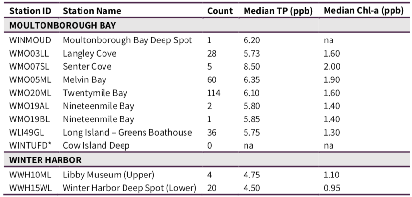
Total Phosphorus
Median total phosphorus in the epilimnion of Moultonborough Bay during the summer season ranges from 5.73 to 8.50 ppb, with the lowest median total phosphorus at Langley Cove (WMO03LL) and the highest median total phosphorus at Senter Cove (WMO07SL; Table 3-6). Median total phosphorus at the two deep spot locations in Winter Harbor, WWH10ML in the northern end of Winter Harbor at the Libby Museum and WWH15WL in the southern end of Winter Harbor, are 4.75 ppb and 4.50 ppb, respectively (Table 3-6). Senter Cove is the only site with existing median total phosphorus above the oligotrophic water quality criterion set by NHDES (see Table 3-3).
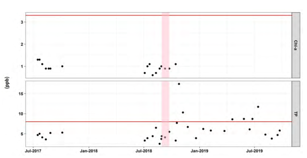
Chlorophyll-a
Median chlorophyll-a in the epilimnion of Moultonborough Bay during the summer season ranges from 1.30 to 2.00 ppb, with the lowest median chlorophyll-a at Long Island (WLI49GL) and the highest median chlorophyll-a at Senter Cove (WMO07SL; Table 3-6). Median chlorophyll-a at the two deep spot locations in Winter Harbor, WWH10ML in the northern end of Winter Harbor at the Libby Museum and WWH15WL in the southern end of Winter Harbor, are 1.10 ppb and 0.95 ppb, respectively (Table 3-6). No sites exceeded the oligotrophic water quality criterion set by NHDES (see Table 3-3).
Secchi Disk Transparency
Secchi disk transparency (or water clarity) has been collected at eight sites in Moultonborough Bay and two sites in Winter Harbor (Figure 3-2). The deepest median water clarity has occurred at the deep spot in Winter Harbor (WWH15WL) in July (10 m), October (9.6 m), and September (9.5 m). The shallowest median water clarity has occurred at site WMO19AL in Moultonborough Bay, ranging from 3.0-4.5 m across all months.
Temperature & Dissolved Oxygen
A common phenomenon for New England lakes is the depletion of dissolved oxygen in bottom waters throughout the summer months. This occurs when thermal stratification prevents warmer, oxygenated surface waters from mixing with cooler, oxygen-depleted bottom waters in a lake. Dissolved oxygen concentrations can change dramatically with lake depth as oxygen is produced in the top portion of a lake (where sunlight drives photosynthesis and oxygen is added through the interface with the atmosphere) while oxygen is consumed near the bottom of a lake (where organic matter accumulates and decomposes). These deep layers are isolated and do not receive oxygen from surface waters or the atmosphere when the lake is thermally stratified. Dissolved oxygen levels below 5-6 ppm (and water temperatures above 24 °C) can stress and reduce habitat for cold-water fish and other sensitive aquatic organisms. The minimum water quality criterion is 5 ppm dissolved oxygen for Class B waters. In addition, anoxia (low dissolved oxygen, <1ppm) at lake bottom can result in the release of sediment-bound phosphorus (otherwise known as internal phosphorus loading), which becomes a readily available food source for algae. While thermal stratification and depletion of oxygen in bottom waters are natural phenomena, it is important to keep tracking these parameters to make sure the extent and duration of low oxygen are not exacerbated by human activities and do not inhibit aquatic life integrity.
Dissolved oxygen and temperature profiles are presented for two sites in Moultonborough Bay (WMO05ML and WMO20ML, 6 and 2 profiles available, respectively) and two sites in Winter Harbor (WWH10ML and WWH15WL, 4 profiles available each). Sporadic dissolved oxygen and temperature profiles exist for other locations in the watersheds but not consistent enough for analysis.
Median dissolved oxygen and temperature at site WMO05ML (below Wingate Brook) shows summer thermal stratification, with high dissolved oxygen and warm water temperatures near the surface followed by a marked decrease in temperature and dissolved oxygen below the metalimnion (i.e., thermocline) between 5 and 10 m depth (Figure 3-3). Dissolved oxygen drops below 5 ppm at approximately 12 m. Water temperature is relatively uniform above 5 m, between 23°C and 24°C. Site WMO20ML (below Twentymile Brook) displays a similar pattern of summer thermal stratification; however, dissolved oxygen drops below 5 ppm higher in the profile, at approximately 9-10 m. Dissolved oxygen then drops below 1 ppm around 15 m.
Dissolved oxygen and temperature at the deep spot in the southern end of Winter Harbor ((WWH15WL) also show summer thermal stratification, with dissolved oxygen dropping to 5 ppm at 15 m depth. The northern end (WWH10ML) is much shallower, at 35 feet, and median dissolved oxygen and temperature profiles suggest that there is no thermal stratification in this embayment. Dissolved oxygen is relatively uniform through the profile between 7 and 8 m, and temperature remains above 22°C throughout the profile. These warm temperatures throughout the water column limit coldwater refugia for fish and aquatic organisms.
