Subwatershed Descriptions
The 369 square miles of land that surround and drain directly into Lake Winnipesaukee contain 10 subwatersheds, four of which are the primary focus of this Management Plan.
The larger Winnipesaukee River watershed measures 485 square miles, and includes the land area draining into the Winnipesaukee River which joins the Pemigewasset River in Franklin, New Hampshire. This management plan focuses on the subwatersheds of Meredith, Paugus and Saunders Bays, but also includes land use/land cover and water quality modeling information for the Lake Waukewan watershed. This section of the plan contains information on:
Refer to the Map Atlas tab of this website to see maps displaying the topography, hydrology, aquifers, etc. of the sub-watersheds.
The Lake Winnipesaukee Watershed Return to Top

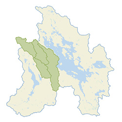
Map by GreenInfo.org
GENERAL DESCRIPTION: The Lake Winnipesaukee watershed, located in Belknap and Carroll Counties in the lakes region of New Hampshire, drains to Lake Winnipesaukee, the largest freshwater body in the state with a size of 44,586 acres and total watershed area of 236,225 acres, or 369 square miles. Key aspects of the watershed are:
Communities: The watershed encompasses a total of eighteen communities; eight of which are shorefront communities comprising approximately 87% of the land area. The eight shorefront communities are Moultonborough, Tuftonboro, Wolfeboro, Alton, Gilford, Laconia, Meredith, and Center Harbor. Additional communities in the watershed include Sandwich, Tamworth, Ossipee, Brookfield, Middleton, New Durham, Gilmanton, New Hampton, Ashland, and Holderness.
Topography: The watershed boundary is characterized by the steep Ossipee Mountain range with elevations of 2,990 ft at Mt. Shaw in the northeast, the floodplain of the Merrymeeting River with an elevation of 542 ft. in the southeast, the Belknap Mountain Range with elevations of approximately 2,400 ft. in the south, and hilly terrain in the northwest with average elevations of ~1,200 ft.
Major Elements: The lake is located at 43°35’56” N Latitude and 71°19’23” W Longitude. It is highly irregular in shape encompassing approximately 240 miles of shoreline (includes the shoreline of islands over 5 acres in size). The surface water area of the lake occupies 44,586 acres; however water from lakes, ponds, streams and rivers in the watershed account for another 11,056 acres, which drain to Winnipesaukee. The total surface water makes up approximately 23.5% of the total watershed area. The major tributaries and waterbodies (highlight on map) contributing large volumes of water to Lake Winnipesaukee include Lake Waukewan, Meredith; Lake Kanasatka, Lees Pond, and Shannon Brook, Moultonborough; Melvin River, Copps Pond, Twentymile Brook, Nineteenmile Brook, Mirror Lake, Tuftonboro; Lake Wentworth, Wolfeboro; Merrymeeting Lake and Merrymeeting River, Alton; Poor Farm Brook and Gunstock Brook, Gilford. The physical shoreline ranges from boulder-strewn to sandy. Some back bay areas have wetland shorelines, mostly in the far northern end of Moultonborough Bay; in Green’s Basin and Lee’s Mills. Looking at the topographical maps of 1909 (links to historical topos), more of the shoreline was wetland; mainly Saunders Bay, areas on Moultonborough Neck, Meredith Neck and Back Bay in Wolfeboro.
Lake Flow: The outlet for the lake is at the Weirs. Drainage flows through the Weirs channel into Paugus Bay. A dam is located at Lakeport at the southwesterly point of the bay. From this location water enters Opechee Lake and continues into the Winnipesaukee River which is diverted by a canal under the City of Laconia into Lake Winnisquam. Lake Winnisquam empties into Silver Lake, which then flows into the Winnipesaukee River. The river merges with the Pemigewasset River in Franklin to form the Merrimack River which then flows southward through Concord, Manchester, Merrimack, Hudson into Massachusetts. In Massachusetts the Merrimack turns eastward and flows through Lowell eventually emptying into the Atlantic Ocean in Newburyport, MA.
Plan Subwatersheds: Meredith Bay, Paugus Bay, and Saunders Bays watersheds form the western side of the Winnipesaukee watershed, comprising a little over 34,000 acres in total within Belknap County. Paugus Bay, which is the drinking water supply for the City of Laconia, is also the drainage portal for the lake.
THE WATERSHED’S CLIMATE: Climate in the lakes region of New Hampshire is considered continental due to prevailing westerly winds, and highly variable due to the mid latitude location. Four distinct seasons are experienced with wide ranges in both daily and annual temperatures. Due to this factor the lake is dimictic, turning over twice each year, once in the spring, and again in the fall, and will stratify during the summer months. Average annual precipitation is approximately 42 inches and is fairly equally distributed throughout the year; however, within the last decade the annual precipitation has been increasing. In 2006, 57.6 inches of precipitation was recorded at the Lakeport Station in Laconia.
LAKE WINNIPESAUKEE SOILS: Soils play an important role in watershed management. The mixture or composition of soil components (clay, loam, sand, silt) impacts the ability of the soil to infiltrate water, and thus reduce runoff.
The USDA Natural Resource Conservation Service (NRCS) groups soils into four (4) main hydrologic soil categories (A, B, C, D) based on estimates of runoff potential. (refer to Appendix: Hydrologic_Soil_Group-Belknap_County.pdf).

Click for a larger image
The majority of soils in Belknap County fall within Hydrologic Soil Group C. Group C soils have a slow infiltration rate when thoroughly wet and therefore a moderately high runoff potential. These consist chiefly of soils having a layer that impedes the downward movement of water or soils of moderately fine texture or fine texture. Water transmission through the soil is somewhat restricted. Group C soils typically have between 20 percent and 40 percent clay and less than 50 percent sand and have loam, silt loam, sandy clay loam, clay loam, and silty clay loam textures. (USDA, National Engineering Handbook, Part 630: Hydrology, Ch. 7 Hydrologic Soil Groups)
Further information on soils can be obtained from the Belknap County Conservation District, and the NRCS Web Soil Survey website.
The Management Plan Subwatersheds Return to Top
| Lake Waukewan | Meredith Bay | Paugus Bay | Saunders Bay | ||||
 |
 |
 |
 |

Lake Waukewan Watershed (HUC 010700020108) Return to Top

A Watershed Management Plan was developed in 2005 for the Lake Waukewan watershed which provides an extensive description of the watershed. The Waukewan watershed was not initially a part of this study, but as the lake outlets into Meredith Bay, it was deemed important to update the land uses on which the modeling analysis is based.
Meredith Bay (HUC 010700020109) Return to Top

The Meredith Bay subwatershed, encompassing approximately 8,791 acres, beginning in the north in Center Harbor, extends southeast to the northwest corner of Governor’s Island, Gilford, and ends at the Weirs in the south. The watershed includes the commercially developed downtown area of Meredith at the intersection of Routes 3 and 25, located along inner Meredith Bay, a large portion of the rural residential area of Meredith Neck on the east side of the bay, and several residential developments along the west side of the bay including Grouse Point, Meredith Bay Colony Club, and Meredith Bay (formerly known as Akwa Vista). The lake area accounts for 30% of the total watershed area, with forested land at 48% being the largest land use category followed by urban or developed land at 20%.
There are four tributaries that feed into Meredith Bay; Hawkins Brook, Mead Brook, Neal Brook, and an unnamed brook in the Wagon Wheel area. In addition to these four tributaries, Lake Waukewan outlets into Meredith Bay through the Mills Falls canal. Besides Lake Waukewan, Hawkins Brook is the major source of inflow to Meredith Bay. Beginning in the most northern area of the watershed in Center Harbor, Hawkins Brook, 3 miles in length, travels south through several wetlands and along the commercially developed Route 3 before crossing under Route 25 and out letting into Meredith Bay.
The other three tributaries are relatively small, and do not contribute significant flows to the bay. An unnamed stream, referred to as Wagon Wheel Brook here, is approximately 1.54 miles in length. The stream begins south of Route 25 just north of Barnard Ridge Rd., crosses Barnard Ridge Rd. approx. 1400’ north of Pinnacle Park Rd., flows through Low Meadow Farm, and crosses under Wagon Wheel Rd. before emptying into the east side of Meredith Bay. Mead Brook is also located on the east side of Meredith Bay; it is a very short stream, 0.8 mi., and outlets at Boardman’s Point near Cummins Cove. The only other tributary in the watershed is Neal Brook located on the west side of Meredith Bay. Neal Brook is approximately 1.6 miles in length and flows in an easterly direction emptying into Meredith Bay near Neal Shore Rd., halfway down Meredith Bay.
Paugus Bay (HUC 010700020110) Return to Top

A detailed planning study was conducted for the City of Laconia Planning and Community Development Department in 2000 by Lobdell Associates, Inc. on the Weirs, Paugus Bay, Opechee Bay, and Winnipesaukee River watersheds.
excerpted from the study:
“The Paugus Bay direct watershed is 6,230 acres, another 1234 acres make up the bay itself. The watershed ends at the dam in Lakeport and begins at the Weirs. However, the entire drainage area of Lake Winnipesaukee (327 sq. mi) drains into Paugus Bay. To this is added the direct watershed, for a total watershed of 337 sq. mi at the dam at Lakeport.
The direct watershed is narrow, running on a northwest-southeast axis with a relatively even distribution of land on either side of the Bay. The most distant point in the watershed is on the east side at 2.7 miles, while on the west side it is 2.1 miles. These areas are located in Gilford and Meredith, respectively.â€
Paugus Bay has the largest percent developed land (25%) out of the four subwatersheds in the study. Single Family Residential makes up 45% of the developed land; commercial development comes in second at 22%, the transportation or road network follows third at 16%, with Multi-family, Industrial, and Urban cultivated making up the remainder.
The developed land is located throughout the watershed, but is mostly concentrated at the top of the watershed at the Weirs, along the eastern shore (Weirs Blvd), and in the Lakeport area at the southern end. On the western side of the watershed there is extensive residential development in the southern Lakeport area, and at South Down, a private residential community of approximately 450 properties occupying 256 acres on the shore of Paugus Bay with 4000 ft of shorefront. Laconia Country Club is also located on the western side of Paugus Bay, but only 40 acres fall within the watershed.
There are four perennial streams of various length that drain into Paugus Bay, two on the western side and two on the eastern. Black Brook, located on the eastern side, originates at Lilly Pond in Gilford. It travels in a southwesterly direction through a very urbanized landscape before emptying into Paugus Bay at Spinnaker Cove. The second stream located on the eastern side of the bay, Langley Brook, drains a relatively small rural subwatershed area of 540 acres, emptying into Langley Cove at the Christmas Island area. The other two perennial streams are unnamed, the first one has its headwaters in the large wetland located on the northwestern side of the bay, draining a subwatershed area of approximately 1,431 acres with its outlet at Pickerel Cove. The second stream located above the Pickerel Cove subwatershed, is very short, of low flow, and empties into Moulton Cove.
Saunders Bay (HUC 010700020107) Return to Top

The Saunders Bay subwatershed encompasses land in Meredith, Laconia, and Gilford. The total watershed area is approximately 17,855 acres; with most of the land area located in Gilford. However the watershed boundary extends north across the lake to include approximately 3000 acres of land in Meredith. Due to this fact, an attempt was made to divide the watershed into two distinct areas; north and south Saunders Bay. While this proved useful for land use analysis, the arbitrary segregation does not necessarily work when analyzing water quality.
Saunders Bay North:Â A large portion of the upper watershed area is in conservation; with the town having recently acquired the Page Pond and Forest land (565 acres) area. The northern subwatershed area is rural residential; an unnamed stream begins in the northern section and flows south into Little Pond. From Little Pond, the stream becomes Page Brook (total length of 2.6 mi), flowing into Page Pond, a pond of approximately 69 acres, then traveling south to empty into the northern end of Saunders Bay.
Saunders Bay South: Gunstock Brook is the only stream of significance emptying into Saunders Bay. The Gunstock Brook subwatershed, located in Gilford, accounts for the majority of the land area of the Saunders Bay subwatershed. Gunstock Brook is a perennial stream 6.44 miles in length that begins at an elevation of approximately 1300 ft. near Piper Mountain and outlets into Saunders Bay. There are at least six seasonal tributaries which feed into it through the course of its meander. The total watershed comprises an area of 5,554 acres, the majority of land use being either forested or residential. A stratified drift aquifer underlies the entire Gunstock Brook watershed.
Historical topographic maps from 1909 show that the area where the brook empties into Saunders Bay was once all wetland; today this area is the location of several marinas, seasonal condominiums, rental properties and the town beach. One other land use of note in the Saunders Bay south subwatershed is the Laconia Municipal Airport.
Three other streams also provide flow into Saunders Bay, although at much less volume. Meadow Brook, which is sandwiched between the airport and Route 11, travels in an easterly direction to outlet into Saunders Bay near the outlet of Gunstock Brook. An unnamed tributary drains the area northeast of what is known as the Meadows, flows under Route 11 into Adder Hole Brook, located behind the Fireside Inn. Adder Hole outlets at the Gilford town beach. The other tributary providing inflow to Saunders Bay is located along Route 11B; it originates out of a wetland area in Laconia, crosses under Route 11B to flow into Saunders Bay near the Laconia/Gilford town line.
Land Use/Land Cover Return to Top
The following table shows the 2009 Land Use-Land Cover based on 2006 and 2008 aerial photography. Four main categories are used to classify land use/land cover; urban, agriculture, forest, and water. The urban category is made up of commercial, industrial, transportation, multi-family, single family, and open space land uses. A detailed overview of how the analysis was done can be found in the Appendices.
| Lake Waukewan | Meredith Bay | Paugus Bay | Saunders Bay North | Saunders Bay South | |
|---|---|---|---|---|---|
| Urban | 951.1 | 1,799.0 | 1,858.0 | 524.0 | 2,229.0 |
| Agriculture | 196.3 | 204.7 | 276.9 | 51.2 | 476.0 |
| Forested | 6,014.0 | 4,180.0 | 4,096.5 | 2,431.0 | 6,663.0 |
| Water | 1,247.9 | 2,618.6 | 1,293.4 | 1,777.0 | 3,336.0 |
Data on the Waukewan Watershed was included in the land use analysis as Lake Waukewan outlets to Meredith Bay, thereby impacting Meredith Bay’s water quality. In addition, the Saunders Bay subwatershed was separated into north and south sections, as very distinct land areas separated by the lake influence each area.
Study Area Population and Development Trends Return to Top
Based on 2008 US Census Bureau data, the estimated population for the three communities in the study area are:
- Meredith: 6,623
- Laconia: 17, 065
- Gilford: 7,450
In addition to permanent resident populations, each community within the three subwatersheds experiences about a three-fold increase in population during the summer season due to tourism, second homes, summer camps, campgrounds, etc.
According to the U.S. Census Bureau data, New Hampshire is fastest growing state in New England, and has grown at a higher rate since 1960 than any of the other five New England States – learn more about this (PDF 1.4mb):
- 43% population increase 1980-2008
- 7% population increase 2000-2008
- 97,025 new single family homes built 1998-2007
Growth has been concentrated in the southern and seacoast areas of the state, but the trend is showing an outward expansion to the north and west.
While the recent economic downturn has affected development activity in the Lakes Region, residential activity continues to make up the most permitting in the Lakes Region, with Laconia, Moultonborough, Alton, Gilford and Meredith issuing the greatest number of permits from 2004-2008.
