Plan Implementation
- Plan Oversight
- Action Plan
- Next Steps for Water Quality Monitoring
- Indicators to Measure Progress
- Estimated Costs & Technical Assistance Needed
5.1 PLAN OVERSIGHT Return to Top
The recommendations of this plan should be carried out by a steering committee like the one assembled for development of this plan. A steering committee should include the leadership of LWA, representatives from the towns (e.g., board of select, planning board), members of the conservation commissions, state and federal agencies or organizations, lake associations, nonprofits, land trusts, schools and community groups, local business leaders, and landowners. The committee will need to meet regularly and work hard to coordinate resources across stakeholder groups to implement management actions. The watershed management plan (especially the Action Plan) will need to be updated periodically (typically every five years) to ensure progress and to incorporate any changes in watershed activities. Measurable milestones (e.g., number of BMP sites, volunteers, funding received, etc.) should be tracked by a steering committee and reported to NHDES on a regular basis.
5.2 ACTION PLAN Return to Top
The Action Plan was developed through the collective efforts of the current steering committee and the support of LWA (Table 5-1). The Action Plan outlines responsible parties, approximate costs4, and an implementation schedule for each recommendation within five major categories: (1) Water Quality Monitoring; (2) Watershed and Shorefront BMPs; (3) Road Maintenance and Training, (4) Municipal Planning and Conservation; and (5) Septic Systems.
5.3 NEXT STEPS FOR WATER QUALITY MONITORING Return to Top
Water quality data are gathered through a coordinated effort among the UNH LLMP, LWA, and local volunteers. However, an annual monitoring program is critical to evaluating the effectiveness of watershed restoration activities and determining if the water quality goal and objectives are being achieved over time. The following recommendations build on the current monitoring program.
Continue/establish regular lake monitoring through LLMP. At a minimum of 3 times per year in the critical growing season (July-September) at lake deep spot sites, collect samples for epilimnion and hypolimnion total phosphorus and epilimnion chlorophyll-a. Aim for biweekly Secchi Disk Transparency readings and monthly dissolved oxygen-temperature profile readings from May 24-Sept 15. Continue to collect surface grab samples for total phosphorus and chlorophyll-a at the nearshore sites or outlets for Winter Harbor (depth = 1 ft). Consider also collecting total nitrogen, dissolved organic carbon, and chloride as part of baseline sampling efforts. Consider including the deep spot of the Basin in regular lake monitoring.
Establish regular tributary monitoring for Moultonborough Bay. At a minimum of 3 times per year in the growing season (May-October) at major tributary outlets to Moultonborough Bay, collect surface grabs samples for total phosphorus and measure/estimate flow at the time of collection. Major tributaries include the Melvin River, Nineteenmile Brook, Twentymile Brook, and Wingate Brook. Consider also collecting turbidity, pH, total nitrogen, dissolved organic carbon, and chloride as part of baseline sampling efforts. Sample tributaries near the outlet but far enough upstream where it appears the possibility of backflow from the larger bay is minimal.
Complete nearshore investigative studies for localized sources of phosphorus in cyanobacteria hotspots. Collect sediment samples to assess the ratio of phosphorus, iron, and aluminum, the risk of internal loading, and the possibility of any spatial patterns in these elements. Collect surface and bottom grab samples for total phosphorus, chlorophyll-a, phytoplankton and periphyton enumeration and speciation, total nitrogen, and dissolved organic carbon at several spatially-representative areas within the area(s) of interest under a variety of conditions during the growing season to capture before, during, and after bloom events. The study should be designed to highlight important spatial and temporal patterns in cyanobacteria bloom occurrence that can better home in on management efforts.
Complete long-term shoreline bank profiling to document shoreline erosion. Establish regular evaluations of shoreline bank heights and undercutting severity around Winter Harbor and possibly Moultonborough Bay to document and track evidence of shoreline erosion and retreat. Assess if changes to boating rules could remediate erosion due to wake action.
Consider expanding lake/tributary monitoring to the early spring and late fall to capture turnover periods. Lake turnover events are important for resetting lake systems through mixing processes that bring nutrients to the top and oxygen to the bottom. These turnover events are already shifting due a changing climate. It will be important to understand when these shifts occur and how these shifts impact summer lake conditions that may be more suitable for blooms. Following summer lake and tributary procedures, collect samples immediately following ice-out in April through early May and again following fall turnover in October through early November.
Consider collecting winter data under the lake ice. Lakes are active even in winter. Algae can grow under the ice and affect nutrient and oxygen availability in the following summer. Following summer lake procedures, collect samples under the ice in February or whenever the ice is likely solid. Send samples for phytoplankton enumeration and speciation.
Complete a study of water current movement throughout the bays. The movement of water throughout Moultonborough Bay and Winter Harbor is complex and mixes regularly with the larger Lake Winnipesaukee system. It is likely that water moves bi-directionally and unequally through multiple outlets depending on the time of year (driven by wind and flow patterns). We recommend collecting depth and flow velocity measurements at set intervals across a transect at each of the major connecting channels of Moultonborough Bay and Winter Harbor at least twice in each season (including winter, if possible) to confirm flow direction and velocity.
Continue regular sampling and 10-year intensive studies assessing the impact of the RIB on Nineteenmile Brook. Continue funding regular sampling and intensive studies assessing the water quality and biological integrity of Nineteenmile Brook downstream of the RIB. This monitoring is critical to assessing the proper functioning of the RIB over time.
Work with NHDES to complete regular 5- to 10-year biological assessments of the major tributaries to Moultonborough Bay. Fish and macroinvertebrate studies should be completed in representative sites along each of the major tributaries to Moultonborough Bay to establish a baseline from which to judge any future changes in biological assemblages. Sensitive organisms can serve as a sentinel for a change in habitat conditions, possibly due to new contamination sources or pressures.
5.4 INDICATORS TO MEASURE PROGRESS Return to Top
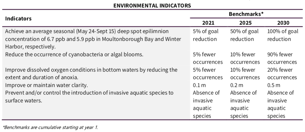
The following environmental, programmatic, and social indicators and associated numeric targets (benchmarks) will help to quantitatively measure the progress of this plan in meeting the established goal and objectives for the Moultonborough Bay and Winter Harbor watersheds. These benchmarks represent short-term (2021), mid-term (2025), and long-term (2030) targets derived directly from actions identified in the Action Plan. Setting benchmarks allows for periodic updates to the plan, maintains and sustains the action items, and makes the plan relevant to ongoing activities. A steering committee should review the benchmarks for each indicator on an ongoing basis to determine if progress is being made, and then determine if the watershed plan needs to be revised because the targets are not being met.
Environmental Indicators are a direct measure of environmental conditions (Table 5-2). They are measurable quantities used to evaluate the relationship between pollutant sources and environmental conditions. They assume that BMP recommendations outlined in the Action Plan will be implemented accordingly and will result in the improvement of water quality. Note that the benchmarks for environmental indicators also reflect protection of water quality from any potential impacts from future development in the watershed.
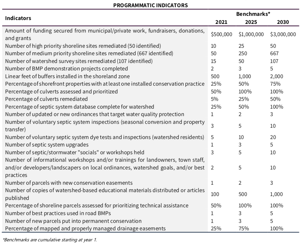
Programmatic indicators are indirect measures of watershed protection and restoration activities (Table 5-3). Rather than indicating that water quality reductions are being met, these programmatic measurements list actions intended to meet the water quality goal.
Social Indicators measure changes in social or cultural practices and behavior that lead to implementation of management measures and water quality improvement (Table 5-4).

5.5 ESTIMATED COSTS & TECHNICAL ASSISTANCE NEEDED
The cost of successfully implementing the plan is estimated at $2.8-$4.9 million over the next ten or more years (Table 5-5). However, many costs are still unknown and should be incorporated to the Action Plan as information becomes available. Estimated costs include both structural BMPs, such as fixing roads and planting shoreline buffers, and non-structural BMPs, such as demonstration tours or workshops and ordinance revisions. Annual BMP costs were included within the cost ranges based on a ten-year total for the initial BMP installation plus ten years of maintenance.

Table 5-5. Estimated total and annual 10-year costs for implementation of the Action Plan. Note: many costs were unknown or dependent on further information; therefore, total estimated costs over the next 10 years are likely underestimated.
Diverse funding sources and strategies will be needed to implement these recommendations. Funding to cover ordinance revisions and third-party review could be supported by municipalities through tax collection (as approved by majority vote by town residents). Monitoring and assessment funding could come from a variety of sources, including state and federal grants (Section 319, ARM, Moose Plate, etc.), municipalities, or donations. Funding to improve septic systems, roads, and shoreland zone buffers would likely come from property owners. As the plan evolves into the future, the formation of a funding subcommittee, as well as a steering committee, will be a key part in how funds are raised, tracked, and spent to implement and support the plan. The following list summarizes several possible outside funding options available to implement the watershed management plan:
- USEPA/NHDES 319 Grants (Watershed Assistance Grants) – This NPS grant is designed to support local initiatives to restore impaired waters (priorities identified in the NPS Management Program Plan, updated 2014) and protect high quality waters. 319 Grants are available for the implementation of watershed-based management plans and typically fund $50,000-$150,000 projects over the course of two years. https://www.des.nh.gov/organization/divisions/water/wmb/was/categories/grants.htm
- NH State Conservation Committee (SCC) Grant Program (Moose Plate Grants) – County Conservation Districts, municipalities (including commissions engaged in conservation programs), and qualified nonprofit organizations are eligible to apply for the SCC grant program. Projects must qualify in one of the following categories: Water Quality and Quantity; Wildlife Habitat; Soil Conservation and Flooding; Best Management Practices; Conservation Planning; and Land Conservation. The total SCC grant request per application cannot exceed $24,000. https://www.mooseplate.com/grants/
- Land and Community Heritage Investment Program (LCHIP) – This grant provides matching funds to help municipalities and nonprofits protect the state’s natural, historical, and cultural resources. https://www.mooseplate.com/grants/
- Aquatic Resource Mitigation Fund (ARM) – This grant provides funds for projects that protect, restore, or enhance wetlands and streams to compensate for impacted aquatic resources. https://www4.des.state.nh.us/arm-fund/
- New England Forest and River Grant – This grant awards $50,000 to $200,000 to projects that restore and sustain healthy forests and rivers through habitat restoration, fish barrier removal, and stream connectivity such as culvert upgrades. https://www.nfwf.org/programs/new-england-forests-and-rivers-fund
- Milfoil and Other Exotic Plant Prevention Grants (NHDES) – Funds are available each year for projects that prevent new infestations of exotic plants, including outreach, education, Lake Host Programs, and other activities. https://www.des.nh.gov/organization/divisions/water/wmb/exoticspecies/categories/grants.htm
- Clean Water State Revolving Loan Fund (NHDES) – This fund provides low-interest loans to communities, non-profits, and other local government entities to improve and replace wastewater collection systems with the goal of protecting public health and improving water quality. A portion of the CWSRF program is used to fund NPS pollution prevention, watershed protection and restoration, and estuary management projects that help improve and protect water quality in NH. https://www.des.nh.gov/organization/divisions/water/wweb/grants.htm
