Management Strategies
The goal of improving water quality to eliminate the presence of cyanobacteria blooms in MBWH watershed will be achieved by treating current point source and nonpoint source pollution from existing development and preventing futures NPS pollution from anticipated new development.
- Structural Nonpoint Source (NPS) Pollution
- Non-Structural Nonpoint Source (NPS) Pollution
- Adaptive Management Approach
4.1 STRUCTURAL NONPOINT SOURCE (NPS) POLLUTION Return to Top
One hundred and seven (107) watershed NPS sites and 717 high to medium priority shoreline properties around Moultonborough Bay and Winter Harbor were identified and documented to have some impact on water quality through the delivery of phosphorus-laden sediment (refer to Section 3.5). As such, structural BMPs are a necessary and important component for the protection of water quality in the watershed. The best approach to treating these NPS sites is to:
- Address high priority watershed and shoreline survey sites with an emphasis on cost-efficient fixes that have a high impact to low cost per kg of phosphorus treated. The BMP matrix (Appendix B) sorts watershed NPS sites by impact-weighted cost to phosphorus reduction ratio. The shoreline survey results are sorted from highest to lowest Shoreline Disturbance Scores.
- Work with landowners to get commitments for treating and maintaining sites. Workshops and tours of demonstration sites can help encourage landowners to utilize BMPs on their own property.
- Work with experienced professionals on sites that require a high level of technical knowledge (engineering) to install and ensure proper functioning of the BMP.
- Estimate pollutant load reductions for each BMP installed.
This approach will help guide the proper installation of structural BMPs in the watershed. More specific and additional recommendations (including public outreach) are included in the Action Plan in Section 5.2. For helpful tips on implementing residential BMPs, see the NHDES Homeowner’s Guide to Stormwater Management (see Additional Resources).
4.1.1 Estimation of Pollutant Load Reductions Needed
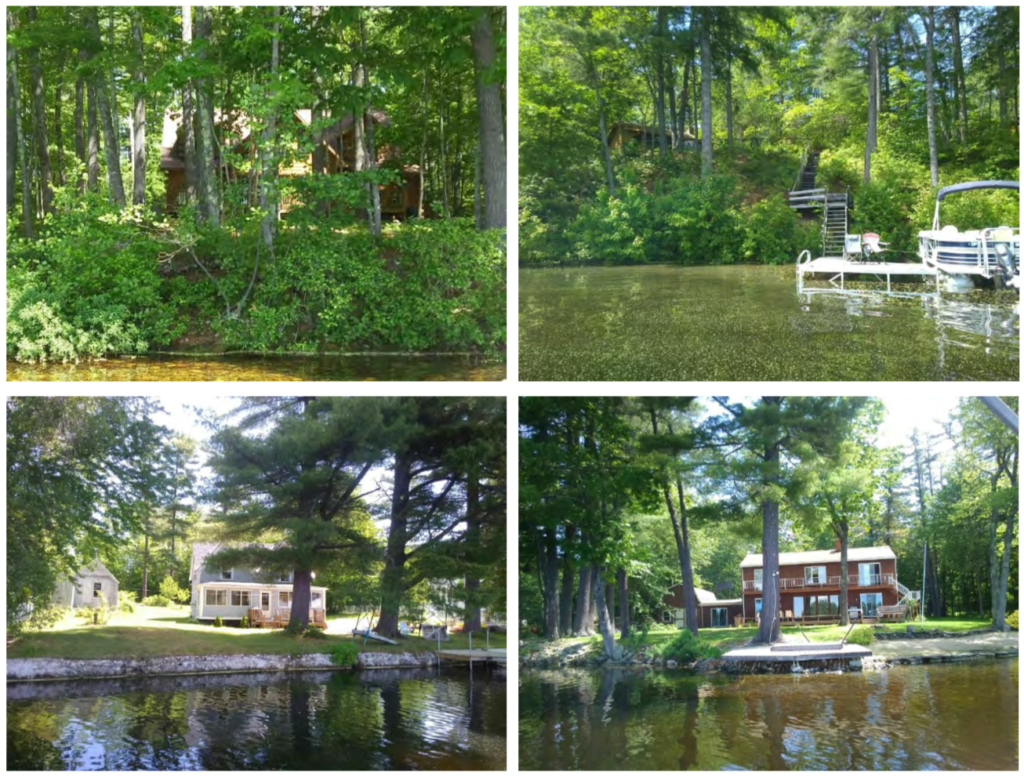
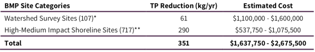
A watershed survey was completed to identify hotspots of pollutant loading to Moultonborough Bay and Winter Harbor. The survey focused on areas of significant sediment erosion. Sediment can carry nutrients, such as phosphorus, to surface waters during runoff events. Treatment of the 107 sites identified would reduce phosphorus loading to Moultonborough Bay and Winter Harbor by an estimated 61 kg/yr. It is important to note that the watershed survey identified erosion sites from public access points (e.g., roads, common areas) unless information was provided by private landowners; it can be assumed that a significant amount of the phosphorus-laden sediment entering these basins likely comes from the cumulative impact of private shoreline properties. To estimate this contribution, a shoreline survey was completed for Moultonborough Bay and Winter Harbor by FBE, volunteers, LWA, and most significantly, by LWA AmeriCorps members Alison Baranovic and Gloria Norcross. All shoreline parcels were evaluated; 717 total parcels were scored as a “high†or “mediumâ€. Estimated total phosphorus reduction from these high and medium sites is 290 kg/yr (Table 4-1).
The strategy for reducing pollutant loading to the lake will be dependent on available funding and labor resources but will likely include a combination of approaches (larger watershed BMP sites and smaller residential shoreline BMP sites) (Table 4-1). Another significant but difficult-to-quantify strategy for reducing phosphorus loading to the lake is revising local ordinances to set LID requirements on new construction. With a dedicated stakeholder group in place and with the help of grant funding, it is possible to achieve target phosphorus reductions and meet the established water quality goal for both Moultonborough Bay and Winter Harbor in the next 10 years.
It is important to note that, while the focus of the objectives for this plan is on phosphorus, the treatment of stormwater and sediment erosion will result in the reduction of many other kinds of pollutants that may impact water quality. These pollutants would likely include:
- Nutrients (e.g. nitrogen)
- Petroleum products
- Bacteria
- Road salt/sand
- Heavy metals (cadmium, nickel, zinc, etc.)
Without a monitoring program in place to measure these other pollutants, it will be difficult to track the success of efforts that reduce these other pollutants. However, there are various spreadsheet models available that can estimate reductions in these pollutants depending on the types of BMPs installed. These reductions can be tracked to help assess long-term response.
4.2 NON-STRUCTURAL NONPOINT SOURCE (NPS) RESTORATION Return to Top
4.2.1 Buildout Potential
“Full Build-out†is a theoretical condition which represents the period when all available land suitable for residential, commercial, and industrial uses has been developed to the maximum conditions permitted by local ordinances. A build-out analysis identifies areas with development potential and projects future development based on a set of conditions (e.g., zoning regulations, environmental constraints) and assumptions (e.g., population growth rate). The results of the build-out analysis can be used as a planning tool to help guide future development activities in a given study area, as well as target specific areas for conservation.
The Moultonborough Bay and Winter Harbor watersheds consist of approximately 5,262 parcels, ranging in size from less than one acre to 830 acres. The build-out analysis shows that, under current zoning regulations, 56% (16,770 acres) of the Moultonborough Bay and Winter Harbor watersheds is buildable. The Tuftonboro Low Density Residential zone has the greatest amount of land available for development at 6,817 acres. FBE identified 2,910 existing buildings within the watershed area, and the build-out analysis projected that an additional 6,385 buildings could be constructed in the future, resulting in a total of 9,295 buildings.
Three iterations of the TimeScope Analysis (a tool facilitating analysis of change over time) were run using compound annual growth rates for 20-, 30- and 40-year periods from 1990-2010 (1.41%), 1980-2010 (1.69%), and 1970-2010 (2.23%), respectively. Full build-out is projected to occur in 2102 at the 20-year growth rate, 2089 at the 30-year growth rate, and 2072 for the 40- year growth rate. This analysis shows that if growth rates, zoning, and other development constraints remain constant, the Moultonborough Bay and Winter Harbor watersheds will attain full build-out by the late 21st century to early-22nd century.
4.2.2 Zoning and Ordinances
Table 4-2 summarizes the results of existing zoning and ordinances for the three primary communities (Moultonborough, Tuftonboro, and Wolfeboro) in the Moultonborough Bay and Winter Harbor watersheds. A full ordinance review is needed for these communities.
4.3 ADAPTIVE MANAGEMENT APPROACH Return to Top
An adaptive management approach, to be employed by a steering committee, is highly recommended for protecting the Moultonborough Bay and Winter Harbor watersheds. Adaptive management enables stakeholders to conduct restoration actions in an iterative manner. Through this management process, restoration actions are taken based on the best available information. Assessment of the outcomes following restoration action, through continued watershed and water quality monitoring, allows stakeholders to evaluate the effectiveness of one set of restoration actions and either adopt or modify them before implementing effective measures in the next round of restoration actions. This process enables efficient utilization of available resources through the combination of BMP performance testing and watershed monitoring activities. Adaptive management features establishing an ongoing program that provides adequate funding, stakeholder guidance, and an efficient coordination of restoration actions. Implementation of this approach ensures that restoration actions are implemented and that surface waters are monitored to document restoration over an extended time.
The adaptive management components for implementation efforts should include:
- Maintaining an Organizational Structure for Implementation. Communication and a centralized organizational structure are imperative to successfully implementing the actions outlined in this plan. A diverse group of stakeholders (an expansion of the current steering committee overseeing plan development) should be assembled to coordinate watershed management actions. This group should include representatives from state and federal agencies or organizations, the towns of Moultonborough, Tuftonboro, and Wolfeboro, conservation commissions, local businesses, and other interested groups or private landowners. Refer to Section 5.1: Plan Oversight.
- Establishing a Funding Mechanism. A long-term funding mechanism to be guided by a steering committee should be established to provide financial resources for management actions. A sub-committee of the steering committee can be dedicated to prioritizing and seeking out funding opportunities. In addition to initial implementation costs, consideration should also be given to the type and extent of technical assistance needed to inspect and maintain structural BMPs. Funding is a key element of sustaining the management process, and, once it is established, the management plan can be fully vetted and restoration actions can move forward. A combination of grant funding, private donations, and municipal funding should be used to ensure implementation of the plan. Refer to Section 5.5 for a list of potential funding sources.
- Determining Management Actions. This plan provides a unified watershed management strategy with prioritized recommendations for restoration using a variety of methods. The proposed actions in this plan should be used as a starting point for grant proposals. Once a funding mechanism is established, designs for priority restoration actions on a project-area basis can be completed and their implementation scheduled. Refer to Section 5.2: Action Plan.
- Continuing and Expanding the Community Participation Process. Plan development has included active involvement of a diversity of watershed stakeholders. Several watershed stakeholders participated in the community forum to develop the Action Plan (refer to Section 1.4). Plan implementation will require continued and ongoing participation of stakeholders, as well as additional outreach efforts to expand the circle of participation. Long-term community support and engagement is vital to successfully implement this plan. Continued public awareness and outreach campaigns will aid in securing this engagement. Refer to Section 5.2: Action Plan.
- Continuing the Long-Term Monitoring Program. A water quality monitoring program is necessary to track the health of surface waters in the watershed. Information from the monitoring program will provide feedback on the effectiveness of management practices. Refer to Section 5.2.1: Water Quality Monitoring.
- Establishing Measurable Milestones. A restoration schedule that includes milestones for measuring restoration actions and monitoring activities in the watershed is critical to the success of the plan. In addition to monitoring, several environmental, social, and programmatic indicators have been identified to measure plan progress. Refer to Section 5.4: Indicators to Measure Progress and Section 3.4: Establishment of Water Quality Goal for interim benchmarks.
