
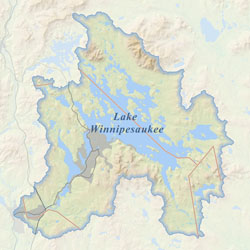
Fed by ancient streams and springs, the crystal clear waters of Lake Winnipesaukee are a magnet for visitors and those who make their home here. The lake is the third largest in New England and is central to a wide range of experiences --from the bustle of small towns to deep wilderness--framed by hundreds of miles of intricate shoreline and over 200 islands.
Introducing the Gateway
Welcome to the Winnipesaukee Gateway– Your “one-stop shopping” source for maps, environmental plans, water quality data, recreational opportunities, and more!
We invite you to check out some of the cool features of the site such as the Monitoring Sites Map for lake data, the Stormwater Footprint Calculator, and the Map Atlas. New information and features are always being added, so check back often, and let us know what you think.
The Winnipesaukee Gateway was created to house the Lake Winnipesaukee Watershed Management Plan. Management Plans are being completed on a sub-watershed basis. Explore the Management Plan tab for more information.
What's New
August 27: Septic Sense – Come out to the Tuftonboro Fire Rescue Department from 6:30 – 8 pm to learn how septic systems work, proper maintenance, the do’s and don’ts, and much more. Gary Spaulding, a licensed septic system designer and installer, will give a very informative talk about what happens after you flush. The Lake Winnipesaukee Association thanks Randy Hilman Homes and Bank of New Hampshire for sponsorship of these important talks. For more information, click here.
June 18: Residential Stormwater Information Fair – Come to the Meredith Community Center from 4:30pm-7:30pm to learn about simple do-it-yourself projects you can implement on your property. Drop in any time to speak with experts or pick up information, or attend one of the featured presentations. For more information contact Donna Van Ness at dvnom@aol.com or visit this link.
