Introduction
Lake Winnipesaukee, located in the lakes region of New Hampshire, is a national and international scenic resource renowned for its remarkable setting, outstanding water clarity, and economic vitality within New England.
Protecting Lake Winnipesaukee requires well-managed watersheds that include native forests and abundant wildlife, with an active and informed community of residents and visitors acting as stewards for the lake. Through the use of smart growth principles, low impact development techniques, stormwater management, land use regulations such as the Comprehensive Shoreland Protection Act (CSPA), and awareness and control of pollution sources, communities can continue to grow, providing a sustainable, vital economy for the region in harmony with the environment.
THE IMPORTANCE OF THE WATERSHED
 The Lake Winnipesaukee watershed is a vital natural and economic resource for the state and the local communities. The lake and surrounding area offers a wide range of recreational activities, from fishing, boating, and swimming on the lake, to camping, hiking, and skiing in the adjacent mountains. Businesses that support these activities provide a livelihood for many people. Restaurants, motels, marinas, campgrounds and ski resorts are just a few of the many industries that rely on the recreational value of Lake Winnipesaukee.
Impacts to the local economy due to the degradation of water quality could have very detrimental effects. A 2007 study entitled “What’s Our Water Worth?” (PDF, 1.1mb) concluded that even a perceived decline in water quality could result in lost retail sales of $25 million, lost income of $8.8 million, and a loss of 396 jobs in the Lakes Region alone.
CHALLENGES FACING THE WATERSHED
Although the overall water quality of the lake is considered pristine, several issues threatening the lake deserve our attention and demand action if we are to enjoy the beauty and benefits of the lake for the long term. Phosphorus levels in the lake have shown an increasing trend; invasive plants such as milfoil inhibit recreational use of the water, are costly to treat, and have the potential to lower property values; and fish and wildlife species are threatened by impacts from human activities such as habitat fragmentation, recreational activities, and pollution.
Learn more about issues facing the watershed .
ABOUT THE LAKE
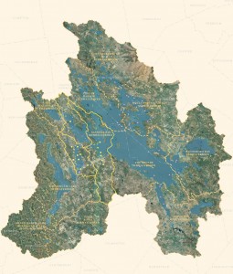
 Lake Winnipesaukee’s total surface area is 44,586 acres. Maximum and mean depths are 180 and 43 feet, respectively. The lake is natural, but raised by damming to an elevation of 504 feet. Eighty-three relatively small tributaries draining a watershed of 215,133 acres provide the main water source for the lake.
There are 240 miles of shoreline (this includes the shoreline length of islands over five acres in area) and about 250 islands (the total number of islands is frequently debated, depending on definition of “islandâ€). The shores and many of the islands are well developed with numerous dwellings, from cottages to mansions, but some areas between the developments remain forested.
Lake Winnipesaukee is a classic glacially formed oligotrophic (this means low fertility) lake. The water is quite clear; average main lake and bay visibility is 27-29 feet. Visibility is slightly less in central portions of Moultonborough Bay (21 feet) and less still in the extreme northern end of this bay (less than 15 feet).
The physical nature of the main-lake shoreline ranges from boulder-strewn to sandy. Some back-bay areas (e.g. the extreme northern end of Moultonborough Bay) have wetland shorelines, but this habitat is limited overall. The lake bottom and reefs/shoals are predominantly ledge, boulders, cobble, gravel, and sand, with softer muck bottoms in basin and back-bay areas.
Emergent and submergent vegetation are sparsely located throughout the lake. Submergents include pondweed, variable milfoil, bladderwort, quillwort, and pipewort; emergents include yellow and white water lily, pickerelweed, and water shield. The greatest concentrations of these aquatics are found in the northern end of Moultonborough Bay.
Quick Facts About Lake Winnipesaukee
[table "6" seems to be empty /]Top photo by Dimitri Sokolenko

